The Ganga or Ganges is the longest river of India flowing over 2,510 kms of mountains, valleys and plains. It originates in the snowfields of the Gangotri Glacier in the Himalayas as the Bhagirathi River. It is later joined by other rivers such as the Alaknanda, Yamuna, Son, Gumti, Kosi and Ghagra. The Ganga river basin (External website that opens in a new window) is one of the most fertile and densely populated areas of the world and covers an area of 1,000,000 sq. kms. There are two dams on the river - one at Haridwar and the other at Farakka. The Ganges River Dolphin is an endangered animal that specifically habitats this river.
The Ganga is revered by Hindus as the most sacred river on earth. Key religious ceremonies are held on the banks of the river at cities such as Varanasi, Haridwar and Allahabad. The Ganga widens out into the Ganges Delta in the Sunderbans swamp of Bangladesh, before it ends its journey by emptying into the Bay of Bengal.
 Gomukh - The Origin          
 
The river, about 2,510 km (1,560 mi) long, rises in a snowfield called THE GANGOTRI GLACIER, situated among three Himalayan mountains all more than 6,706 m (22,000 ft) high. It issues as the Bhagirathi River from an ice cave, 3,139 m (10,300 ft) above sea level, and falls 67 m per km (350 ft per mi). About 16 km (10 mi) from the source is Gangotri, the first temple on its banks and a traditional resort of pilgrims. At the village of Devaprayag, 214 km (133 mi) from the source, the Bhagirathi joins the Alaknanda to form the Ganges.
    
    
The Ganges, after descending 2,827 m (9,276 ft), or an average of about 11 m per km (60 ft per mi), flows west to the border of the great plain of Hindustan at Haridwar, 253 km (157 mi) from its source and 312 m (1,024 ft) above sea level. From Haridwar it continues south and then south-east to Allahabad after a winding course of 785 km (488 mi), made un navigable by shoals and rapids.
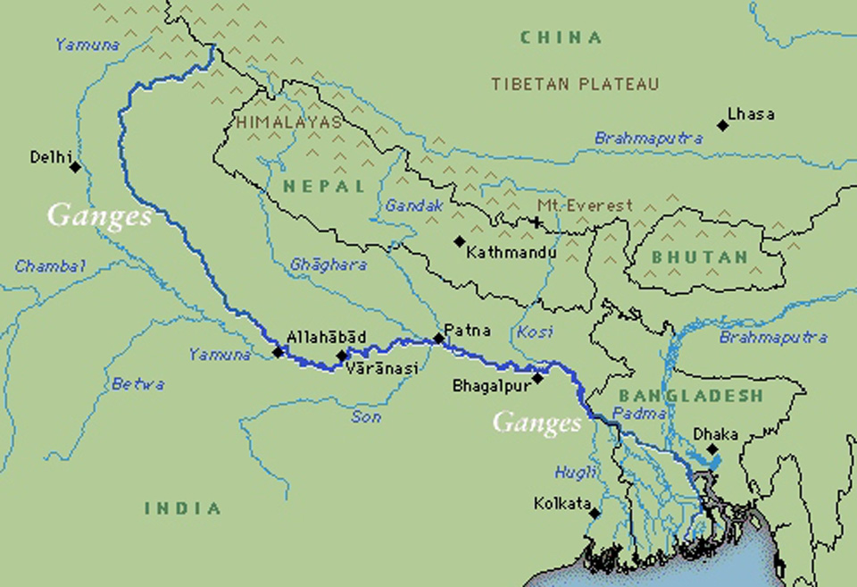
At Allahabad, the Ganges is joined by the Yamuna River from the south-west, and from that point the river flows east past Mirzapur, Varanasi, Ghazipur, Patna, Monghyr, and Bhagalpur, 

:Fig: Tha Path of Ganga River(Image from National Portal of India)
receiving on the south the Son River and on the north the Gumti, Ghaghara, Gandak, and Kosi rivers. In the Rajmahal Hills, at the head of the Ganges delta, 906 km (563 mi) from Allahabad, the river turns south and begins a descent of 455 km (283 mi) to the Bay of Bengal. Near Pakaur, the Bhagirathi (assuming the former name of the river) and, 114 km (71 mi) lower down, the Jalangi River branch off from the main stream, and after individual courses of 193 km (120 mi) each, unite again to form the Hooghly River, the westernmost and principal channel of navigation, on which the city of Calcutta stands. The main branch of the Ganges, from which numerous minor tributaries flow, continues in Bangladesh, as the Padma River, to the town of Shivalaya (Sibalay), where it unites with the Jamuna, the main branch of the Brahmaputra, and finally runs through the Meghna estuary into the Bay of Bengal.
Between the Meghna estuary and the western channel of the Hooghly River are the several mouths of the deltaic channels. The northern portion of the delta is fertile and well cultivated. The southern section consists mostly of swampland, known as the Sundarbans, because of the sundari tree that flourishes there. The marshes are inhabited by several species of crocodile. From year to year the Ganges exchanges old channels for new ones, particularly in the alluvial basin of its lower reaches. Like the Brahmaputra, the Ganges has been adversely affected by the deforestation of valleys in its upper course, causing flooding and an increase in sedimentation around the riverΓÇÖs delta in Bangladesh. This sometimes combines with coastal flooding caused by cyclones to produce inundation of the delta area on a massive scale.
The Ganges is regarded by Hindus as the most sacred river in the world. Many important religious ceremonies are held in cities on its banks, including Varanasi, Haridwar, and Allahabad.
